


How can large property owners in the GCC transform complex spaces into intuitive, user-friendly environments? Furthermore, the region’s booming infrastructure, from mega-malls to sprawling healthcare campuses, creates significant navigation challenges. Consequently, indoor navigation wayfinding apps provide a powerful digital solution. This technology enhances facility visitor guidance through precise digital mapping and real-time location services.
Across the Gulf, facilities management standards continue to rise. Moreover, visitor expectations for seamless experiences are higher than ever. Therefore, implementing smart wayfinding systems is no longer a luxury. Indeed, it is a strategic necessity for competitive advantage and operational excellence. Additionally, these systems integrate with broader smart building initiatives prevalent in the UAE and Saudi Arabia.
At Allianze HR Consultancy, we understand that technology implementation requires skilled talent. Furthermore, our expertise in technical recruitment supports the digital transformation of GCC facilities. We’ve successfully placed 10,000+ professionals across UAE, Saudi Arabia, Qatar, and Kuwait. Moreover, our 5+ years of GCC expertise supports clients from 50+ countries. Therefore, our Ministry of External Affairs (India) RA license ensures compliance. Consequently, contact our recruitment specialists for expert guidance on building your technical teams.
Understanding Modern Facility Navigation Challenges
Large properties inherently create orientation difficulties. First-time visitors often struggle to locate specific rooms, departments, or amenities. Additionally, traditional signage has clear limitations. It is static, costly to update, and can contribute to visual clutter. Moreover, in emergencies, static signs provide no dynamic guidance.
Visitor frustration directly impacts brand perception and operational efficiency. For example, delayed appointments in hospitals reduce patient throughput. Similarly, lost shoppers in malls decrease retail spending. Furthermore, inefficient internal staff movement wastes productive time. Therefore, a digital solution addresses multiple pain points simultaneously.
Key challenges for GCC facilities include:
- Multilingual user bases requiring intuitive, language-agnostic interfaces.
- Complex building layouts with multiple wings, floors, and restricted areas.
- High visitor volumes during peak seasons and events.
- Integration with existing building management and security systems.
- Compliance with local data privacy regulations like the UAE’s PDPL.
Addressing these issues requires a strategic approach. Consequently, digital wayfinding systems offer a robust, scalable answer.
Indoor Navigation Wayfinding Apps Strategic Overview
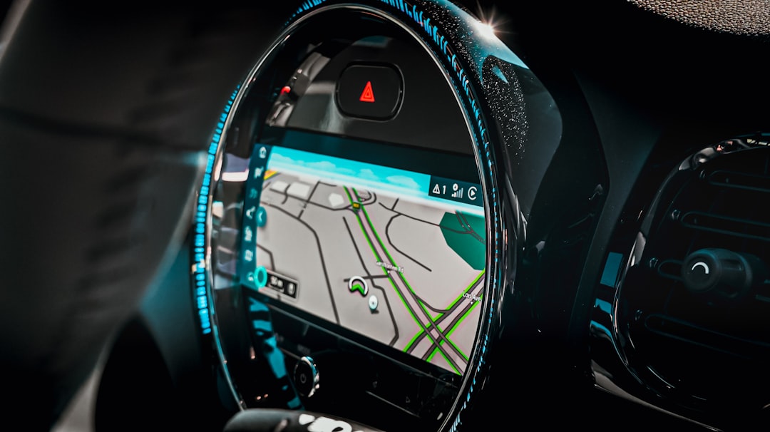
Indoor navigation wayfinding apps are sophisticated software platforms. They guide users within large buildings using smartphones or kiosks. Furthermore, these applications utilize various technologies like Bluetooth beacons, Wi-Fi RTT, or magnetic positioning. They create interactive digital maps for enhanced facility visitor guidance.
The core value proposition is immense. Specifically, these apps turn spatial confusion into confident navigation. They provide turn-by-turn directions to any mapped point of interest. Moreover, they can display real-time information like queue times or room availability. Additionally, they support accessibility features for visually impaired users.
Strategic benefits for GCC employers include:
- Enhanced visitor satisfaction and improved customer experience scores.
- Reduced burden on information desk and security staff.
- Valuable analytics on visitor flow patterns and hotspot identification.
- Increased safety through emergency evacuation routing.
- New monetization avenues via promoted locations and advertising.
Implementing such a system is a significant project. Therefore, it requires careful planning and the right technical talent, which aligns with our recruitment services.
Legal Framework and Compliance Standards
Deploying digital tracking technology involves important legal considerations. Firstly, data privacy is paramount. The UAE’s Personal Data Protection Law (PDPL) and similar regulations in Saudi Arabia govern location data collection. Moreover, employers must ensure transparent data usage policies. Consequently, user consent mechanisms must be clear and unambiguous.
Furthermore, accessibility is not just ethical but often a legal requirement. The International Labour Organization standards emphasize inclusive workplaces. Additionally, local disability rights laws mandate reasonable accommodation. Therefore, apps must include features like screen reader compatibility and high-contrast modes.
Compliance extends to infrastructure installation. For instance, mounting beacons or sensors must adhere to local UAE green building regulations and fire codes. Moreover, electronic waste from outdated hardware requires proper disposal. Partnering with knowledgeable vendors ensures adherence to all Saudi Ministry of Labor regulations and local mandates.
Key compliance steps include:
- Conducting a Data Protection Impact Assessment (DPIA).
- Implementing privacy-by-design principles in the app architecture.
- Securing explicit consent for location data collection and usage.
- Ensuring cybersecurity measures protect the network and user data.
- Regularly auditing systems against evolving international labor standards.
Indoor Navigation Wayfinding Apps Best Practices
Successful implementation of indoor navigation wayfinding apps follows proven methodologies. First, begin with a comprehensive site audit and mapping exercise. Furthermore, accuracy is the foundation of user trust. Therefore, invest in precise floor plan digitization. Moreover, clearly define all points of interest, pathways, and restricted zones.
Secondly, prioritize user experience (UX) design. The interface must be intuitive for a diverse demographic. Additionally, consider offering multiple language options common in the GCC. Also, provide both app-based and kiosk-based access points. This ensures inclusivity for visitors without smartphones or data plans.
Integration is another critical best practice. Specifically, connect the wayfinding system with other building systems. For example, integrate with calendar systems for room booking. Similarly, link with asset tracking for equipment location. Moreover, connect with IAQ monitors to guide users to better-ventilated areas.
Essential best practices include:
- Maintaining and updating digital maps after any renovation or layout change.
- Using clear, universally understood icons alongside text labels.
- Providing offline functionality for areas with poor signal penetration.
- Training facility staff to assist users and promote app adoption.
- Analyzing usage data to continuously optimize routes and points of interest.
Following these guidelines maximizes return on investment. Consequently, it ensures the system delivers lasting value for facility visitor guidance.
Documentation and Processing Steps
Deploying a wayfinding system requires meticulous project management. Initially, define the project scope and key performance indicators (KPIs). Furthermore, assemble a cross-functional team. This team should include IT, facilities management, security, and marketing representatives. Moreover, securing executive sponsorship is crucial for resource allocation.
The next phase involves technical documentation. First, create detailed floor plan drawings in compatible digital formats. Additionally, document all hardware specifications for beacons, servers, and kiosks. Also, draft data flow diagrams and privacy policies. Subsequently, develop user acceptance testing (UAT) plans and training manuals for staff.
Procurement and installation follow documentation. This includes sourcing hardware, selecting a software vendor, and managing logistics. Furthermore, on-site installation must be scheduled to minimize operational disruption. Moreover, rigorous testing in a staged environment precedes the full launch. Finally, a phased rollout often proves most effective.
Core documentation includes:
- Project charter with defined objectives, budget, and timeline.
- Technical requirements specification (TRS) for vendors.
- Risk assessment and mitigation plan.
- Data privacy impact assessment and consent forms.
- Post-launch support and maintenance service level agreements (SLAs).
Proper documentation ensures clarity and accountability. Therefore, it is vital for project success and long-term system management.
Indoor Navigation Wayfinding Apps Implementation Timeline
A realistic timeline for indoor navigation wayfinding apps spans several months. Typically, the process takes four to six months from conception to launch. However, complex facilities may require longer. The initial planning and scoping phase usually lasts four to six weeks. Furthermore, this includes stakeholder interviews and needs analysis.
The procurement and design phase follows. This stage involves selecting technology partners and designing the user experience. Moreover, it includes creating the initial digital maps. Consequently, this phase often takes six to eight weeks. Simultaneously, the development of the custom application or configuration of the platform occurs.
Installation and testing are critical final stages. Hardware deployment and software integration require careful coordination. Additionally, user acceptance testing identifies bugs and usability issues. Therefore, allocate three to four weeks for thorough testing. Finally, a soft launch with a pilot group provides valuable real-world feedback before full deployment.
Sample timeline breakdown:
- Weeks 1-6: Planning, Requirements Gathering, and Vendor Selection.
- Weeks 7-12: System Design, UX/UI Development, and Content Creation.
- Weeks 13-16: Hardware Installation and Software Configuration.
- Weeks 17-20: Comprehensive Testing, Staff Training, and Pilot Launch.
- Weeks 21-24: Full Deployment, Marketing Promotion, and Analytics Review.
Adhering to a structured timeline manages expectations. Moreover, it ensures thorough execution at each step for optimal facility visitor guidance.
Common Challenges and Solutions
Implementing indoor positioning systems presents predictable hurdles. Firstly, technical accuracy can be problematic. Signal interference from building materials like metal or thick concrete affects performance. However, hybrid positioning systems combining Bluetooth, Wi-Fi, and sensor fusion mitigate this issue. Moreover, regular calibration maintains accuracy over time.
Secondly, user adoption is a frequent challenge. Visitors may not download a dedicated app. Therefore, offering progressive web app (PWA) functionality accessible via browser is key. Additionally, strategically placed QR codes at entrances can trigger instant access. Furthermore, promoting the app’s benefits through signage increases uptake.
Thirdly, ongoing maintenance costs concern facility managers. Hardware batteries deplete and require replacement. Software also needs updates and security patches. Consequently, building a maintenance clause into the vendor contract is essential. Additionally, training in-house staff for basic troubleshooting reduces long-term reliance on vendors.
Effective solutions include:
- Conducting a pre-deployment site survey to identify signal dead zones.
- Designing an onboarding process that takes less than 30 seconds.
- Creating a dedicated budget line for annual maintenance and updates.
- Establishing a feedback loop where users can report map inaccuracies.
- Integrating with popular platforms like Google Maps for seamless outdoor-to-indoor transition.
Anticipating these challenges enables proactive management. Therefore, it ensures the navigation solution remains effective and valuable.
Expert Recommendations for Success
To ensure project success, start with a clear business case. Furthermore, define measurable ROI metrics beyond user satisfaction. For example, track reduced staff time spent giving directions. Additionally, monitor increased foot traffic to promoted tenant locations. Moreover, measure decreased late arrivals for appointments.
Secondly, prioritize data from day one. The analytics generated by indoor navigation wayfinding apps are incredibly valuable. They reveal traffic patterns, bottlenecks, and underutilized spaces. Consequently, use this data to inform operational decisions. For instance, adjust cleaning schedules or retail tenant placements based on actual footfall.
Finally, view the system as a platform, not just a tool. It can evolve to offer more services. For example, integrate with ticketing for events or enable food ordering for delivery to a user’s location. Furthermore, leverage the platform for targeted, location-based communications and promotions.
Top expert recommendations:
- Partner with vendors experienced in similar GCC property types and regulations.
- Appoint an internal “champion” to oversee the system and drive engagement.
- Schedule quarterly reviews to assess performance against KPIs and plan enhancements.
- Ensure the technology infrastructure aligns with broader smart city initiatives.
- Consider future-proofing by choosing scalable solutions that can add new features like AR navigation.
Following these recommendations positions your property at the forefront of operational innovation. Therefore, it delivers superior facility visitor guidance and a modern user experience.
Frequently Asked Questions About Indoor Navigation Wayfinding Apps
What is the primary benefit of indoor navigation wayfinding apps?
The core benefit is transforming complex spaces into navigable environments. Furthermore, these apps significantly reduce visitor stress and confusion. Consequently, they improve overall satisfaction and operational efficiency for large facilities.
What technology is used for indoor positioning?
Common technologies include Bluetooth Low Energy (BLE) beacons, Wi-Fi Round-Trip-Time (RTT), and magnetic field mapping. Moreover, smartphone sensors (accelerometer, gyroscope) aid in tracking movement. Often, a hybrid approach provides the most accurate and reliable facility visitor guidance.
How do these systems handle user privacy?
Reputable systems are designed with privacy-by-design. They typically use anonymous session IDs rather than personal identifiers. Additionally, they require explicit user consent before navigation begins. Furthermore, data is often aggregated and anonymized for analytics purposes to comply with regulations like the UAE’s PDPL.
Can these apps work without an internet connection?
Many advanced apps offer limited offline functionality. For example, pre-downloaded maps can be accessed. However, real-time routing updates and point-of-interest information typically require a data connection. Therefore, providing facility Wi-Fi enhances the user experience significantly.
What is the typical cost range for implementation?
Costs vary widely based on property size and solution complexity. Factors include the number of beacons, custom app development, and kiosk hardware. Therefore, a detailed site survey and quotation from a specialist vendor are essential for an accurate budget.
How does Allianze HR support such technology projects?
We recruit the technical talent needed to deploy and manage these systems. Our expertise includes sourcing IoT specialists, UX designers for digital mapping, and facilities technology managers. Moreover, we ensure candidates understand the regional professional recruitment resources and compliance landscape. Therefore, we help you build the team that turns the technology into a success.
Partner with Allianze HR for Navigation Success
Implementing indoor navigation wayfinding apps is a strategic investment in your property’s future. It directly enhances the visitor experience and operational intelligence. Furthermore, in the competitive GCC market, such technological adoption sets a premium standard.